SmarterWX Collaborate
Coordinate your capital works schedules
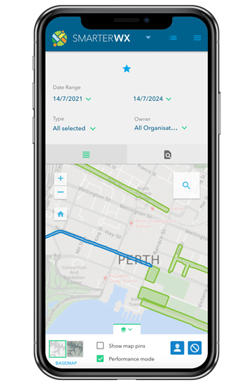
Collaborate on projects – all from the same map
SmarterWX Collaborate operates under the simple principle of ‘information is power’.
Backed by the world’s leading smart mapping technology, SmarterWX Collaborate takes excavation and capital works planning data – from different utilities, councils, and constructions groups – and presents the information as a common operating picture. It is a commanding view and one that not only informs but promotes internal and cross-agency collaboration.
Accessed via a secure, scalable Cloud platform – in real-time from any desktop or mobile device – SmarterWX Collaborate keeps you connected to the information that matters, whether you’re in the field or in the office.
A connected view of your capital works interests
-
Quickly and easily upload your data
A clever publishing wizard makes uploading and managing your data a breeze.
-
Be notified of new exclusion zones
Receive automatic alerts on changes that impact your project schedule.
-
Easily identify opportunities to collaborate
Be notified of opportunities to coordinate works with other groups.
-
Access premium reporting capabilities
Track, explore and share information relating to project statistics and savings.
-
Easy ‘single sign-on’ access
Enjoy centralised user management and single sign-on with SAML integration.
-
Connect with your other GIS platforms
Integrate with your existing GIS platforms, so you can use your own basemap and layers.
Transforming project workflows
SmarterWX Collaborate has revolutionised how project managers plan, deliver, monitor, and report on major programs of work. By seeing the full picture, project managers can now effectively coordinate activities with other program leaders from within their organisation or other external groups.
Learn how more than 50 NSW councils, utilities and agencies have used SmarterWX Collaborate to ensure roads are only dug up once when undertaking maintenance and repairs. Read more »
Improve your project planning
Interested to learn how SmarterWX Collaborate can introduce greater efficiencies to your next project?
SmarterWX Collaborate FAQs
No one likes the bad press that goes with roads being repeatedly dug up — that’s why having visibility over other projects planned in the area helps reduce the inconvenience typically experienced by the community for public works projects.
With smart mapping at its core, SmarterWX Collaborate presents layers of capital works data as a common operating picture to a growing user base of engineering, utilities, government and non-government agencies across Australia.
The platform highlights collaboration opportunities as well as scheduling conflicts instantly and facilitates communication between project owners — allowing efforts to be consolidated where possible.
SmarterWX uses advanced geospatial processing to immediately identify opportunities to collaborate with other organisations for works scheduled on the same street.
You can receive real-time email notifications of these opportunities, which means you will always have access to the latest information when planning your projects.
This allows you to reach out to other agencies to collaborate on projects and share costs of resurfacing roads.
In addition to providing a comprehensive view of planned projects, SmarterWX Collaborate also outlines exclusion zones — areas where works are not allowed.
Exclusion zones allow agencies to share additional information about planned events or community activities that could conflict with planned works.
When setting the dates for your water main upgrade, it’s good to have visibility over these potential activities as they could have an impact on your permits.
The SmarterWX community is growing every day
Subscribe to SmarterWX news
Stay in the loop with all the latest news, user case studies, and information on upcoming events.