Before You Dig Australia (BYDA) recently introduced a new service for members and users, speeding up enquiry lodgement through the BYDA API. Using the BYDA API, you can automate the process of submitting jobs to the referral service, improving productivity and accuracy.
All Before You Dig Australia members will receive an initial allocation of 1,000 free BYDA API calls, and the credits are valid until the end of the financial year. If you’re not a BYDA member, sign up for your allocation.
What can I do with my free BYDA API calls?
The new BYDA API unlocks the advanced enquiry creation features in SmarterWX Locate. With these features, you’ll be able to sketch and lodge multiple job sites at once, and even upload your enquiries from a spatial data file.
For those of you using ArcGIS, an integration called Geovonic Connect makes things even easier. The Geovonic Connect application can also be used to submit an enquiry in BYDA, simply by clicking on existing features within an ArcGIS web map.
What is SmarterWX Locate?
SmarterWX Locate is designed to help regular users of BYDA to streamline workflows, increase in-field and in-office productivity, and most importantly – reduce risk on-site. Instead of using the public BYDA service, you can use SmarterWX Locate to access a range of enhanced features specifically designed for teams who need to make many enquiries.
If your team is logging multiple jobs, SmarterWX Locate can help reduce the effort in managing and sharing referrals. Enquiries lodged by one team member are immediately available for everyone in your team.
SmarterWX Locate also collates – in a single view – all responses from your enquiry. No longer do emails flood back into your mailbox. Instead, anyone in your team can view all the responses online.
With the new BYDA API and SmarterWX Locate, there’s more than one way to get the job done.
Sketching multiple dig sites
Submitting multiple dig sites with BYDA involves going through the lodge enquiry workflow multiple times – for each dig site. I cringe just thinking about it. However, with SmarterWX Locate, you can sketch the area for each job on a map before submitting.
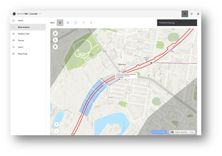
In Figure 1, the user has drawn four job sites. Once the sketching is complete, all enquiries will be submitted. This avoids repeating the same step multiple times, as you only need to complete the enquiry details form once. If you have ever had to complete multiple submissions, you’d know how draining repeating the enquiry over and over can be.
If you think you’re having a bad day, pity the person who recorded 380 individual BYDA enquiries in one day. No doubt this took many hours. If she had used SmarterWX Locate the process would have been much simpler, faster and a lot easier.
For complex construction projects or for large areas, rather than getting every response notification separately (and let’s face it, that could be hundreds), you may want to get a consolidated report by individual job site. Keeping your job sites smaller, makes it easier to review underground assets, helping construction teams manage risk and improve planning.
Uploading from GIS data
More and more, organisations are planning and visualising their upcoming works in a GIS system.
If you export your job sites to a shapefile (.shp), SmarterWX Locate will upload the file to automatically generate each of the shapes on the map. Your reference field for each job can also be set based on attributes contained in the shapefile.
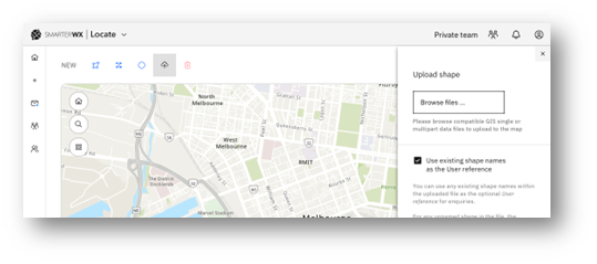
Uploading your dig sites in this way reduces the chances of errors when sketching the boundaries and helps ensure that nothing gets missed.
Using your own basemap
The BYDA referral service provides basemap options most suitable for working in built-up areas. However, when it comes to greenfield development or works in rural areas, it can be difficult to accurately locate your job site on the map.
SmarterWX Locate includes a feature allowing you to customise the basemap as the canvas for sketching. Custom basemaps allow you to add aerial imagery, include linear reference marks to a long rail or pipeline job, or use your own maps for a major construction project.
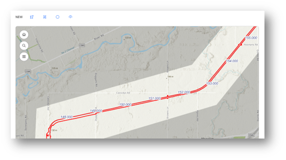
Figure 3 features a map with custom layers showing the extent of the construction zone in red and linear reference marks. This feature makes it easier to find the location of each planned work package. In contrast, using off-the-shelf basemaps makes accurate sketching of each enquiry’s area considerably harder.
Lodging enquiries from your own ArcGIS web apps
As someone who has worked in business improvement and software development for over two decades, I’ve learned to listen. Part of my job as Chief Innovation Officer is to create applications, workflows and business systems which address people’s problems. Both SmarterWX and Geovonic Connect were born out of users’ frustration with consolidating and sharing information on construction sites.
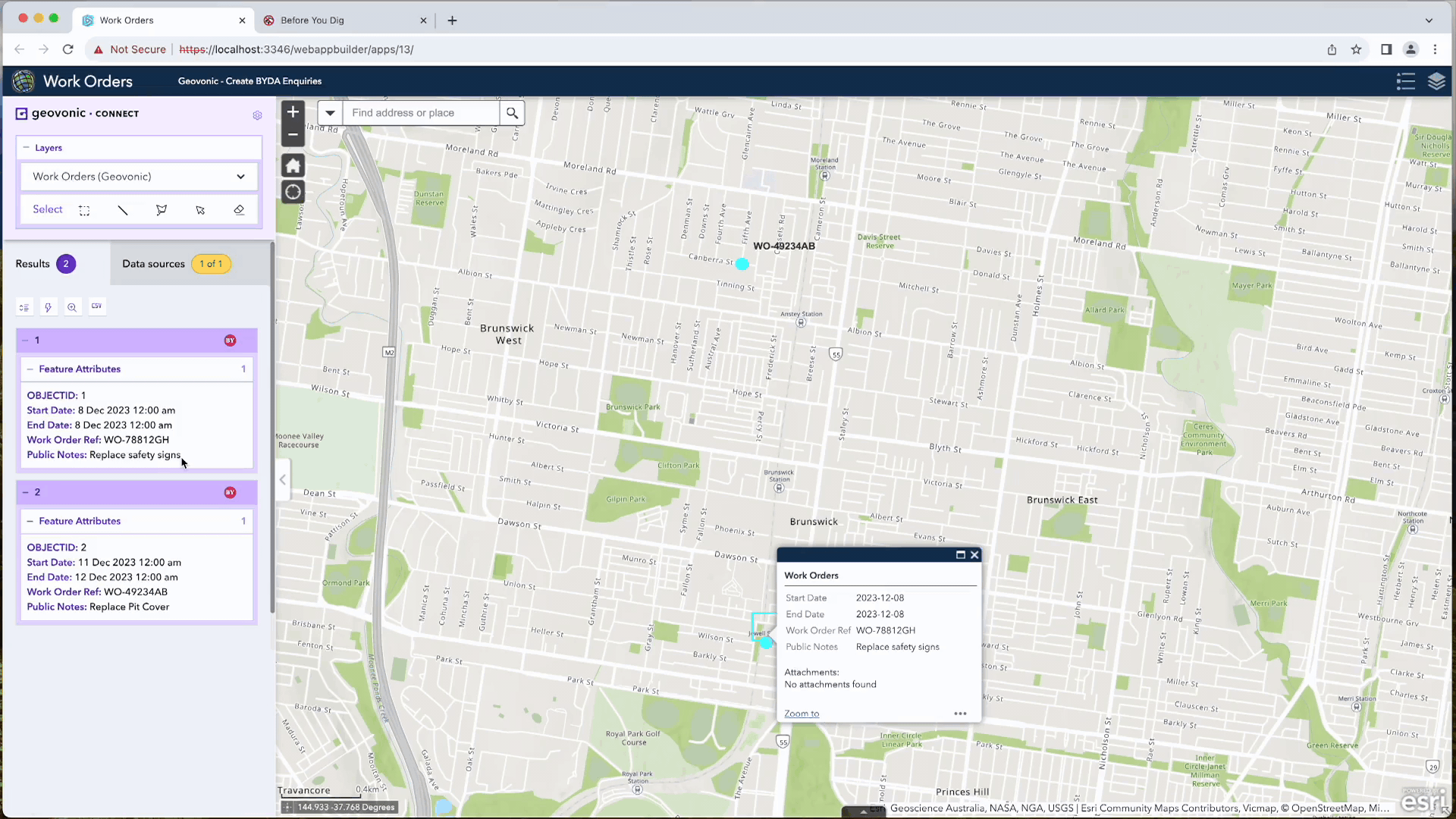
Imagine if a web map showed planned works and you could click on one of the features and use that information to pre-populate an enquiry into the BYDA referral service.
It is possible with the BYDA API and Geovonic Connect.
Geovonic Connect is an extension for ArcGIS Experience Builder and Web AppBuilder applications, providing real-time integration with multiple business systems.
To improve the user experience, we’ve added a new connector for Geovonic Connect that will automatically copy a feature from your web map into the BYDA referral service.
The release of the new BYDA API Service and the accompanying free credits will streamline your workflows.
By combining these credits with SmarterWX Locate or Geovonic Connect you can save time, save headaches, reduce risk, and improve efficiency.
If you’d like to know more, explore the SmarterWX site, visit Geovonic, or connect with me on LinkedIn: Gary Johnson.